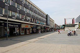
Borough of Basildon
distrikt i England, Storbritannien
Borough of Basildon är ett distrikt (motsvarande kommun) i grevskapet Essex i England, Storbritannien. Distriktet har 188 848 invånare (2022)[2].
| Borough of Basildon | |
| Distrikt | |
| Land | |
|---|---|
| Riksdel | England |
| Region | Östra England |
| Ceremoniellt grevskap | Essex |
| Administrativt grevskap | Essex |
| Koordinater | 51°35′N 0°28′Ö / 51.59°N 0.47°Ö |
| Huvudort | Basildon |
| Area | 110 km²[1] |
| Folkmängd | 188 848 (2022)[2] |
| Befolkningstäthet | 1 717 invånare/km² |
| Tidszon | UTC (UTC+0) |
| - sommartid | BST (UTC+1) |
| GSS-kod | E07000066 |
| Geonames | 7290689 |
|
Läge i grevskapet Essex
| |
Större orter förutom huvudorten Basildon är Billericay och Wickford.
Civil parishes
redigeraStaden Basildon ingår inte i någon civil parish. Resterande del av distriktet är indelat i nio civil parishes: Billericay, Bowers Gifford and North Benfleet,[3] Great Burstead and South Green, Little Burstead, Noak Bridge, Ramsden Bellhouse, Ramsden Crays, Shotgate[4][5] samt Wickford.
Källor
redigera- ^ ”Estimates of the population for the UK, England, Wales, Scotland, and Northern Ireland (Mid-2022)” (på engelska) (xls). Landyta, avrundad till hela km². Office for National Statistics. 26 mars 2024. https://www.ons.gov.uk/peoplepopulationandcommunity/populationandmigration/populationestimates/datasets/populationestimatesforukenglandandwalesscotlandandnorthernireland. Läst 25 juni 2024.
- ^ [a b] ”Estimates of the population for the UK, England, Wales, Scotland, and Northern Ireland (Mid-2022)” (på engelska) (xls). Office for National Statistics. 26 mars 2024. https://www.ons.gov.uk/peoplepopulationandcommunity/populationandmigration/populationestimates/datasets/populationestimatesforukenglandandwalesscotlandandnorthernireland. Läst 25 juni 2024.
- ^ Ordnance Survey linked data
- ^ ”Shotgate”. MapIt. http://mapit.mysociety.org/area/61080.html. Läst 26 maj 2016.
- ^ ”Arkiverade kopian”. Arkiverad från originalet den 3 mars 2016. https://web.archive.org/web/20160303233958/http://neighbourhood.statistics.gov.uk/dissemination/viewFullDataset.do?instanceSelection=03070&productId=779&$ph=60_61&datasetInstanceId=3070&startColumn=1&numberOfColumns=4&containerAreaId=790385. Läst 27 mars 2012.

