Aveiro
Aveiro (portugisiskt uttal: [aˈvejɾu] or [ɐˈvɐjɾu]
(![]() lyssna)) är en stad i mellersta Portugal, belägen vid atlantkusten.
Staden är huvudorten i Aveiros kommun och residensstad i Aveiros distrikt.
[2]
lyssna)) är en stad i mellersta Portugal, belägen vid atlantkusten.
Staden är huvudorten i Aveiros kommun och residensstad i Aveiros distrikt.
[2]
| Aveiro | |||
| Stad | |||
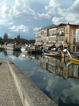
En av kanalerna i Aveiro
| |||
|
|||
| Land | |||
|---|---|---|---|
| Underregion | Baixo Vouga | ||
| Distrikt | Aveiro | ||
| Flod | Vouga | ||
| Koordinater | 40°38′N 8°39′V / 40.633°N 8.650°V | ||
| Area | 199,77 km² | ||
| Folkmängd | 73 559 (2006)[1] | ||
| Befolkningstäthet | 368 invånare/km² | ||
| Grundades (eller fick stadsrättigheter) |
1515 | ||
| Geonames | 8010417 2742611 | ||
| Gammal provins | Beira Litoral | ||
| Kommunal helgdag | 12 maj | ||
| Antal församlingar | 14 | ||
|
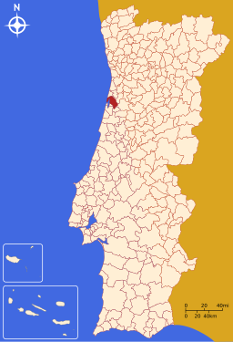
Aveiros läge i Portugal
| |||
| Webbplats: http://www.cm-aveiro.pt/ | |||
Aveiros kommun har 80 978 invånare. [3]
Etymologi
redigeraNamnet Aveiro kommer från det latinska ortsnamnet Averius, som i sin tur kommer från det keltiska ordet aber, med betydelse "flodutmynning". [4]
Stadsdelar
redigeraStaden Aveiro är indelat i 10 stadsdelar och kommundelar - freguesias. [5]
- Aradas
- Cacia
- Eixo e Eirol
- Esgueira
- Glória e Vera Cruz
- Oliveirinha
- Requeixo, Nossa Senhora de Fátima e Nariz
- Santa Joana
- São Bernardo
- São Jacinto
Kommunikationer
redigeraMotorvägen A 1 passerar Aveiro och leder norrut till Porto och söderut till Lissabon. Motorvägen A 25 utgår från staden och går österut mot Viseu och Guarda. [6] [7]
Från järnvägsstationen i Aveiro utgår tågtrafik mot Porto, Braga, Guimarães, Lisboa och Faro. [8]
Referenser
redigera- ^ Instituto Nacional de Estatística uppgifter från 2006.
- ^ ”Aveiro” (på portugisiska). Infopédia. Porto Editora. https://www.infopedia.pt/apoio/artigos/$aveiro?uri=toponimia/Aveiro. Läst 11 maj 2022.
- ^ ”Censos 2021 - Resultados provisórios” (på portugisiska). Censos 2021. INE (Portugals statistiska centralbyrå). https://www.ine.pt/scripts/db_censos_2021.html. Läst 11 maj 2022.
- ^ ”Aveiro” (på portugisiska). Infopédia. Porto Editora. https://www.infopedia.pt/dicionarios/toponimia/Aveiro. Läst 11 maj 2022.
- ^ ”Mapa dos municípios (Karta över kommunerna) - Aveiro” (på portugisiska). Associacão Nacional dos Municípios Portugueses (Portugisiska kommunförbundet). https://www.anmp.pt/municipios/municipios/municipios-de-a-a-v/. Läst 4 juni 2022.
- ^ ”Estradas de Portugal (Vägkarta – Portugal)” (på portugisiska). Infraestruturas de Portugal. Arkiverad från originalet den 28 januari 2014. https://web.archive.org/web/20140128080223/http://www.estradasdeportugal.pt/index.php/pt/phoca-download-/category/10-prn?download=411%3Aprn-2000. Läst 3 juni 2022.
- ^ ”Concessões das Infraestruturas Rodoviárias – Portugal 2019” (på portugisiska). AMT – Autoridade da Mobilidade e dos Transportes. sid. 30-31. https://www.amt-autoridade.pt/media/3012/relatorio_das_concessoes_2019_amt.pdf. Läst 3 juni 2022.
- ^ ”Aveiro, Portugal” (på engelska). Google Maps. https://www.google.com/maps/place/Aveiro,+Portugal/@40.6356357,-8.6938956,18246m/data=!3m1!1e3!4m5!3m4!1s0xd23980ed5b2e78d:0x3042e1cd013c1f07!8m2!3d40.6405055!4d-8.6537539?hl=en. Läst 4 juni 2022.
- ^ ”Port facilities” (på engelska). Porto de Aveiro. https://portodeaveiro.pt/instalacoes-portuarias/en/. Läst 4 juni 2022.
- ^ ”Aveiro” (på engelska). Find a Port. https://www.findaport.com/port-of-aveiro. Läst 4 juni 2022.
Externa länkar
redigera- Wikimedia Commons har media som rör Aveiro.


