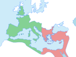
Fil:Theodosius I's empire.png
Theodosius_I's_empire.png (563 × 406 pixlar, filstorlek: 28 kbyte, MIME-typ: image/png)
Filhistorik
Klicka på ett datum/klockslag för att se filen som den såg ut då.
| Datum/Tid | Miniatyrbild | Dimensioner | Användare | Kommentar | |
|---|---|---|---|---|---|
| nuvarande | 14 juni 2019 kl. 15.05 |  | 563 × 406 (28 kbyte) | SuperSucker | fix - date added |
| 24 maj 2013 kl. 18.15 |  | 563 × 406 (24 kbyte) | Giorgi Balakhadze | Edited Turkery-Syria Turkery-Iraq borders. | |
| 16 juli 2007 kl. 11.32 |  | 563 × 406 (11 kbyte) | Nihad Hamzic | Greatly reduced image size by reducing color domain. It caused only a minor white color shift. | |
| 13 december 2006 kl. 00.01 |  | 563 × 406 (54 kbyte) | Electionworld | {{ew|en|Geuiwogbil}} Map of the boundaries of the western and eastern Roman empires after the death of Theodosius I, in 395 AD. {{legend|#B53636|Western Roman Empire}} {{legend|#8F36B5|Eastern Roman Empire}} Made personally from blankmap Europe v3, using |
Filanvändning
Följande 4 sidor använder den här filen:
Global filanvändning
Följande andra wikier använder denna fil:
- Användande på af.wiki.x.io
- Användande på als.wiki.x.io
- Användande på ar.wiki.x.io
- Användande på ast.wiki.x.io
- Användande på azb.wiki.x.io
- Användande på be.wiki.x.io
- Användande på bg.wiki.x.io
- Användande på bn.wiki.x.io
- Användande på bs.wiki.x.io
- Användande på ca.wiki.x.io
- Användande på cs.wiki.x.io
- Användande på da.wiki.x.io
- Användande på de.wiki.x.io
- Användande på diq.wiki.x.io
- Användande på el.wiki.x.io
- Användande på en.wiki.x.io
Visa mer globalt användande av denna fil.


