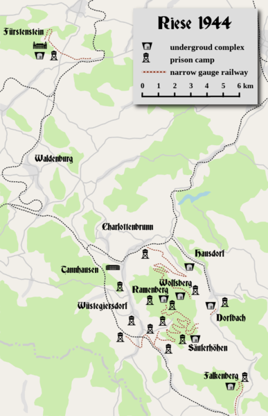
Fil:Project Riese - map.PNG

Storlek på förhandsvisningen: 387 × 599 pixlar. Andra upplösningar: 155 × 240 pixlar | 310 × 480 pixlar | 646 × 1 000 pixlar.
Originalfil (646 × 1 000 pixlar, filstorlek: 301 kbyte, MIME-typ: image/png)
Filhistorik
Klicka på ett datum/klockslag för att se filen som den såg ut då.
| Datum/Tid | Miniatyrbild | Dimensioner | Användare | Kommentar | |
|---|---|---|---|---|---|
| nuvarande | 20 november 2018 kl. 00.21 |  | 646 × 1 000 (301 kbyte) | Les7007 | Improved graphics |
| 2 december 2014 kl. 15.54 |  | 435 × 360 (223 kbyte) | Les7007 | Redundant part cropped + new info | |
| 26 oktober 2014 kl. 21.22 |  | 495 × 482 (339 kbyte) | Les7007 | new info | |
| 20 september 2012 kl. 15.34 |  | 495 × 482 (338 kbyte) | Les7007 | new info | |
| 11 juni 2010 kl. 15.35 |  | 495 × 482 (339 kbyte) | Les7007 | PNG compression was applied to reduce the size of the file | |
| 7 juni 2010 kl. 14.52 |  | 495 × 482 (701 kbyte) | Les7007 | Improved graphics | |
| 14 oktober 2009 kl. 13.27 |  | 479 × 444 (391 kbyte) | Les7007 | {{Information |Description={{en|1=The map of the Owl Mountains with underground complexes of the project Riese. It is a derivative work of the uploader based upon [http://www.planiglobe.com/omc_set.html Planiglobe]. The licence is [http://www.planiglobe.c |
Filanvändning
Följande sida använder den här filen:
Global filanvändning
Följande andra wikier använder denna fil:
- Användande på cs.wiki.x.io
- Användande på da.wiki.x.io
- Användande på es.wiki.x.io
- Användande på fr.wiki.x.io
- Användande på it.wiki.x.io
- Användande på mk.wiki.x.io
- Användande på nl.wiki.x.io

