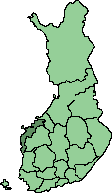
Fil:Location of Pohjanmaa in Finland.png
Location_of_Pohjanmaa_in_Finland.png (230 × 400 pixlar, filstorlek: 3 kbyte, MIME-typ: image/png)
Filhistorik
Klicka på ett datum/klockslag för att se filen som den såg ut då.
| Datum/Tid | Miniatyrbild | Dimensioner | Användare | Kommentar | |
|---|---|---|---|---|---|
| nuvarande | 22 augusti 2007 kl. 08.48 |  | 230 × 400 (3 kbyte) | Ö | Reverted to earlier revision |
| 19 augusti 2007 kl. 13.51 |  | 2 000 × 3 500 (374 kbyte) | QWerk | == Summary == A Large map of Finnish provinces. Original map made by Ningyou (Image:Finnish provinces.png Category:Maps of Finland == Licensing == {{PD-self}} | |
| 18 augusti 2005 kl. 21.10 |  | 230 × 400 (3 kbyte) | Tomisti | Location of Pohjanmaa Region, Finland. Picture made by the uploader, based on the template. {{GDFL}} Category:Location Maps for Finnish Regions |
Filanvändning
Följande sida använder den här filen:
Global filanvändning
Följande andra wikier använder denna fil:
- Användande på nn.wiki.x.io

